Tactical Context: The Dual-Axis Interdiction Campaign
The synchronized operations on and leading up to June 13, 2026, highlight Ukraine’s dual-track approach to exhausting Russian logistics. By matching long-range strategic interdiction against deep-water energy hubs with precise tactical disruption of local bottlenecks, the campaign aims to throttle the transit of heavy military cargo and fuel to the southern front.
1. Strategic Deep Strike: Volna Terminal Approach Envelopes
Long-range Ukrainian one-way attack UAVs (such as the Liutyi and Bober platforms) bypassed regional air defense clusters by executing low-altitude, waypoint-heavy ingress vectors over the Black Sea.
- Ingress Corridor: Western maritime approach, dipping low beneath radar horizons before banking sharply northeast to strike the Volna export infrastructure.
- Target Infrastructure: Fuel storage tanks and loading piers, heavily disrupting the maritime distribution of refined petroleum products intended to bypass the restricted Kerch Strait crossings.
2. Tactical Interdiction: The Chonhar Corridor Lockdown
Closer to the line of contact, Ukraine’s Special Operations Forces and specialized drone units systematically targeted the alternative logistics grid connecting occupied Kherson with the Crimean peninsula.
- Main Span Invalidation: Following consecutive strikes on June 6–7 and June 9, 2026, the primary concrete deck of the Chonhar Bridge (R-218 highway) sustained heavy structural perforations, halting standard military vehicle throughput.
- Pontoon Bypass Interdiction: Satellite imagery confirmed that Russian forces attempted to mask and deploy a temporary tactical pontoon crossing directly underneath and adjacent to the disabled main span. Precision drone strikes over the last 48 hours successfully targeted these makeshift bypass links, causing localized fragmentation damage and severe fuel/supply gridlock.
Chronological Operational Timeline
The timeline below tracks the progression of this interdiction campaign leading up to the current operational standstill:
Initial Chonhar Span Disruption
June 6-7, 2026
Ukrainian Special Operations Forces execute an overnight precision attack on the primary Chonhar road bridge. Planet Labs satellite imagery reveals deep impact scarring and structural compromise across the central deck section, forcing occupation authorities to suspend heavy transport.
Secondary Bridge Strike & Pontoon Detection
June 9, 2026
A subsequent wave of Ukrainian UAVs strikes the Chonhar corridor again. Ground reports confirm damage to the newly deployed pontoon bypass systems hidden adjacent to the main span, driving military logistics to revert to longer, secondary land routes through Armiansk and Perekop.
Flank Interdiction Campaign
June 11, 2026
The interdiction campaign expands eastward and westward. Strikes disable bridge crossings spanning the North Crimean Canal near Preobrazhenka and Myrno, isolating alternative transit routes and exacerbating localized fuel distribution crises across northern Crimea.
Total Logistics Lockdown
June 13, 2026
Synergized deep-strike operations hit the Volna terminal alongside targeted precision denial of the remaining Chonhar pontoon systems. Heavy cargo traffic remains severely bottlenecked, creating a critical logistics pause for forward-deployed Russian assets.
Logistics Corridor Comparison
To illustrate the systemic impact of these strikes on the southern supply framework, the table below outlines the operational state of the primary transit options available to supply lines as of June 13, 2026:
| Logistics Route | Primary Function | Current Operational Status (June 13, 2026) |
| Chonhar Corridor (R-218) | Direct link from Rostov-on-Don to Simferopol; heavy armor and fuel transport. | Disabled. Main concrete spans heavily holed; adjacent pontoon bypass systems shattered by precision drone interdiction. |
| Perekop / Armiansk Route | Western land bridge connector into northern Crimea. | Saturated. Operational but facing extreme gridlock as all heavy military and commercial transport is diverted here. |
| North Crimean Canal Bridges | Regional auxiliary distribution networks (Preobrazhenka/Myrno). | Partially Compromised. Recent drone strikes have introduced structural weight limitations, rendering them unsafe for heavy tracked armor. |
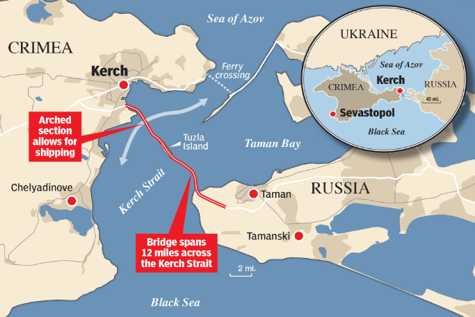
| Kerch Strait Bridge | Eastern strategic backbone connecting mainland Russia to Crimea. | Restricted. Highly vulnerable to maritime and aerial threats; Moscow continues to restrict its use for highly volatile hazardous cargo like bulk fuel. |
Technical Specifications: Long-Range UAV Ingress Profiles
The specialized long-range platforms driving these deep-strike vectors demonstrate highly evolved flight profiles optimized for bypassing densified theater air defenses:
- Low-Altitude Maritime Ingress: Platforms maintain an altitude of less than 50 meters above sea level across the Black Sea transit leg, masking their radar cross-section against shore-based early warning arrays.
- Waypoint Saturation: Asymmetrical routing utilizing up to 12 distinct navigational dog-legs. This shifts the entry vector away from predictable straight-line corridors, forcing local air defense batteries to rapidly re-orient.
- Terminal Terminal Velocity: Terminal guidance combines anti-jamming GPS/INS units with optoelectronic terrain-matching systems, ensuring precise delivery against reinforced stationary targets like petroleum storage cells and bridge anchoring piles even in high-EW (electronic warfare) environments.